")
")
. This zone separated North and South Vietnam during the Vietnam War and served as a tense border region.")
The Vietnamese Demilitarized Zone (DMZ) was established as a dividing line between North and South Vietnam as a result of the First Indochina War. During the Second Indochina War (popularly known as the Vietnam War), it became important as the battleground demarcation separating North Vietnamese territory from South Vietnamese territory.
Vietnamese DMZ map
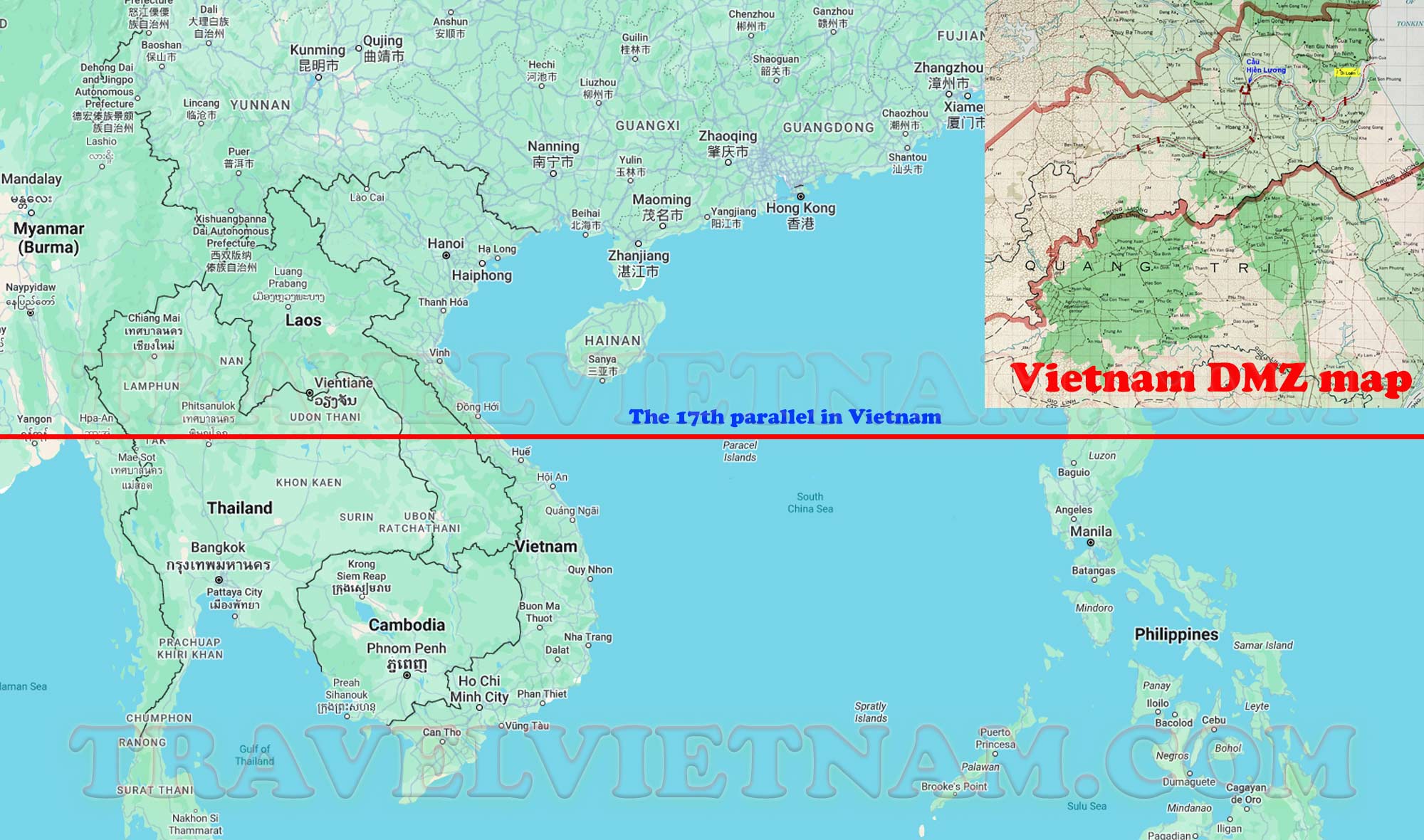
Located in Central Vietnam, the demilitarized zone (DMZ Vietnam) is a strip of land that stretches from Laos to the coast. It is situated near Dong Ha, between Phong Nha and Hue.The 17th parallel demilitarized zone (known internationally as the Vietnam Demilitarized Zone) is a demilitarized zone along the two banks of the Ben Hai River that was established on July 21, 1954, under the Agreement. Geneva returned to Indochina in 1954, with the initial purpose of being a temporary military demarcation line separating the gathering area between the forces of the Democratic Republic of Vietnam and the French army and allied forces on the one hand.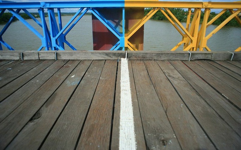
The boundary between these two zones was established at the Ben Hai River, the area within 5 km on either side of the border was declared to be a demilitarized zone. Troops of both governments were barred from this area.In principle, this demilitarized zone is 1.6km (one mile) wide on each side from the banks of the Ben Hai River, starting from the Vietnam-Laos border to the East Sea coast. It is expected that the temporary demarcation line will be removed after the general election two years later. However, it actually became a border dividing Vietnam during the war. On July 2, 1976, the National Assembly of Vietnam officially abolished the existence of the demilitarized zone at the 17th parallel when establishing the Socialist Republic of Vietnam.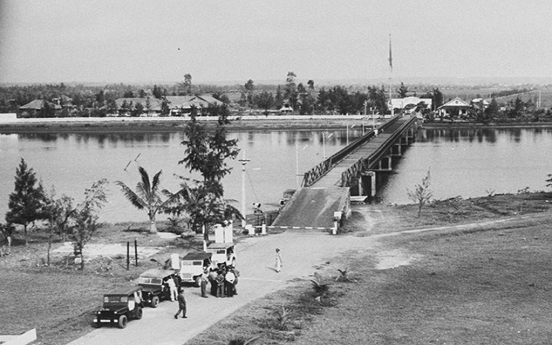
Currently, some points located in this area have been restored into tourist attractions in Vietnam. There are now only a few remaining vestiges of DMZ Vietnam, but it is still an important place for tourists to visit due to its historical significance during the Vietnam War. Some well-known destinations in the area include the Quang Tri Citadel and the Vinh Moc tunnels. Quang Tri is the first region in Vietnam to focus on promoting DMZ tourism. Vietnam DMZ tours are popular among international visitors and offer a unique way to learn about the history of Vietnam and the impact of the Vietnam War.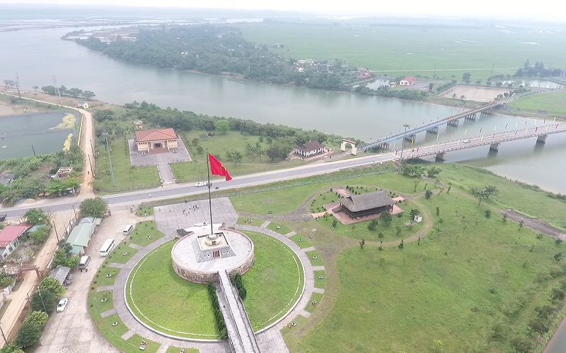
The 17th parallel in Vietnam
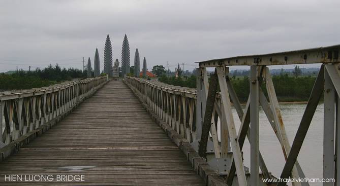 The Hien Luang Bridge, a symbol of the division of Vietnam. This bridge on the 17th parallel once served as a tense crossing point between North and South Vietnam.
The 17th parallel in Vietnam, also known as the Ben Hai River, marked more than just a geographical division; it symbolized a nation split by ideologies and a prelude to a conflict that would shape the modern world. Established by the Geneva Accords of 1954, this line was never meant to be a permanent border but became the de facto boundary between North and South Vietnam.
The area around the 17th parallel, including the Vietnamese Demilitarized Zone (DMZ), was a site of intense conflict during the Vietnam War, bearing witness to the resilience and turmoil of a nation in the throes of change. Today, it stands as a historical testament to the pursuit of peace and unity.
The 17th parallel in Vietnam became synonymous with the division of a nation during the Vietnam War. Here's a quick breakdown:
- The Line: Established in 1954 by the Geneva Accords, it aimed to temporarily separate communist North Vietnam from the anti-communist South Vietnam.
- DMZ Buffer: A Demilitarized Zone (DMZ) existed along the parallel, intended to prevent conflict.
- Symbol of Division: Despite its intended purpose, the 17th parallel became a battleground during the Vietnam War (1955-1975).
For those looking to delve deeper into the history of the Vietnam War, the 17th parallel offers a poignant journey through time, where every landmark tells a story of courage, sacrifice, and the enduring hope for reconciliation.
The DMZ Campaign (1969–1971)
The DMZ Campaign of 1969-71 was a pivotal series of military operations during the Vietnam War, marking a period of intense conflict along the Vietnamese Demilitarized Zone (DMZ). This campaign saw the United States Army, Marine Corps, and the Army of the Republic of Vietnam (ARVN) engage in strategic battles against the People's Army of Vietnam (PAVN) in the northern Quảng Trị Province.
The campaign's objective was to disrupt PAVN supply routes and fortifications in the DMZ area. It involved a combination of ground assaults, artillery barrages, and aerial bombardments. The departure of the 3rd Marine Division in late 1969 led to an increased role for the U.S. Army, which continued operations until the gradual withdrawal in 1971, eventually transferring full responsibility to the ARVN.
The DMZ Campaign is remembered for its operational and for the challenges faced by American and South Vietnamese forces in the rugged terrain under harsh weather conditions. It stands as a testament to the complexities of the Vietnam War and the relentless pursuit of tactical advantage in a protracted conflict. Despite the lack of a formal declaration, the campaign ultimately failed to stop North Vietnam from supporting revolutionary movements in the South. This ultimately led to the complete collapse of the U.S. and South Vietnamese forces after four years of conflict, paving the way for the unified Vietnam we see today.
Sightseeing in DMZ Vietnam
Hien Luong Bridge
Crosses the Ben Hai River at the middle of the DMZ and marks the former border between North and South Vietnam from 1954 to 1972 when the North Vietnamese Army captured Dong Ha town in the 1972 Easter Offensive and pushed the border to the Thach Han river in Quang Tri town, some 20 miles further south. During the partition of Vietnam, the bridge was painted with the two different colors. There is a monument on the north side.
Vinh Moc Tunnels
When the War took place in Vinh Moc from 1966 to 1972, the United States Army released over 9,000 tons of bombs in the area, with a ratio of 7 tons of bombs on average per person. But the local people didn't want to leave or lose their motherland. In 1965, they began to dig tunnels using simple tools beginning and completed them within two years. The total length of the tunnels is nearly 2,000 m long with 6 entrances to the tops of hills and 7 entrances to the South China Sea.
The complex grew to include wells, kitchens, and rooms for each family and spaces for healthcare. Around 60 families lived in the tunnels; as many as 17 children were born inside the tunnels. Today, the tunnels are a tourist attraction and can be visited on organized tours. Beside individual tours to the tunnels, they are regularly part of full-day trips, starting from Hue to explore the Demilitarized Zone. In comparison to the Cu Chi tunnels, walking through the Vinh Moc tunnels is a lot more comfortable, because they are situated in a less humid climate zone and the height of the tunnels allows even western tourists to stand upright.
Truong Son National Cemetery
The largest martyr cemetery gathering grave of volunteer youth, soldiers who built up and fought to protect the legendary Ho Chi Minh Trail during American War. More than 10,000 graves dot these hillsides, each marked by a simple white tombstone headed by the inscription martyr. The gravestones of 13 war heroes, including two women, are singled out in a separate area. All other soldiers are buried in five zones according to the part of Vietnam they came from, with each zone further subdivided in to provinces. During the war, they would have been buried near where they killed, but after reunification their remains were transferred here or to one of the four other national cemeteries. However, many graves are empty, simply bearing names – a fraction of Vietnam’s 300,000 soldiers missing in action.
Camp Carroll
The largest fire base of the U,S Marines below the DMZ. There were 24 big guns there to provide fire support for the Marines. It was named after a Marine Corps captain who was killed while trying to seize a nearby ridge. Its gargantuan 175m cannons were used to shell targets as far away as Khe Sanh.
The Rockpile
A karst rock outcropping near the former South Vietnamese DMZ. It rises to an elevation of 240 meters (790 ft) MSL, about 210 meters (690 ft) above the surrounding terrain. Its relatively inaccessible location, reached only by helicopter, made it an important United States Army and Marine Corps observation post and artillery base from 1966 to 1968.
Dak Rong Bridge
Crossing the Dak Rong River 13km east of the Khe Sanh bus station, this bridge was rebuilt in 2001 and bears a marker hailing its importance as a conduit for the Ho Chi Minh Trail. The road to Aluoi was once part of the trail and heads southeast from the bridge.
Khe Sanh Combat Base
A United States Marine Corps outpost in South Vietnam used during the Vietnam War. The airstrip was built in September 1962. Fighting began there in late April 1967 with the hill fights, which later expanded into the 1968 Battle of Khe Sanh. U.S. commanders hoped that the North Vietnamese Army would attempt to repeat their famous victory at the Battle of Dien Bien Phu, and the battle ended as a failure for the North Vietnamese Army. The defense of Khe Sanh became one of the largest sieges of the war and commanded heavy international attention in the media one of several climactic phases of the Tet Offensive. On 5 July 1968, Khe Sanh was abandoned, the U.S. Army citing the vulnerability of the base to enemy artillery. However, the closure permitted the 3rd Marine Division to construct mobile firebase operations along the northern border area.
In 1971, Khe Sanh was reactivated by the U.S. Army (Operation Dewey Canyon II) to support Operation Lam Son 719, the South Vietnamese incursion into Laos. It was abandoned again sometime in 1972. In March 1973, American officials in Saigon reported that North Vietnamese troops had rebuilt the old airstrip at Khe Sanh and were using it for courier flights into the south. As of 2009, Khe Sanh Combat Base is a museum where relics of the war are exhibited. Most of the former base is now overgrown by wilderness or coffee and banana plants.
Check out some more Vietnam tours for veterans here
Last updated on 2024-03-22 04:57:06.
Other Vietnam Attractions
- Discover the Charm of Dalat: 10 Must-See Attractions in Vietnam's Central Highlands
- Cu Chi Tunnels
- Mai Chau
- Top 9 Must-See Destinations in Vietnam & 14 Off-the-beaten-path Places to Visit
- Temple of Literature Hanoi: Everything You Want to Know
- Sapa's Top Attractions Demystified by local experts
- The Perfume Pagoda
- Ha Giang
- Chau Doc
- Things You Should Know About Cat Ba Island, Vietnam 2024
Questions & Answers
Thank you!
When you visit the site, our local guide will give you better explanation and information (from Vietnam side). Please email us to [email protected], then we could share some photos of Hien Luong Bridge both during the war and today to you.
RSS feed for questions to this post